
iHunter New Brunswick
In-app purchases
1K+
Downloads

Everyone
info
About this app
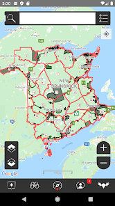
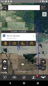
iHunter New Brunswick gives hunters and outdoor enthusiasts a new view into New Brunswick's wildlife management zones. By overlaying the WMZs on top of base maps, users can see their current location and which WMZ they are in. Dive deeper into specific WMZs to see which big game, bear, small game, and game bird seasons are open. Contribute to the map by adding your own waypoints to keep track of hunting spots, past animal harvests, and landowner contact information.
Features:
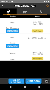
- Includes regulation summary for the current season (free updates every year)
- View WMZs on top of base of big-game, predator and game bird seasons
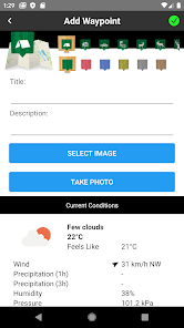
- Add waypoints to the map at your current location, known GPS locations, or where you tap and hold
- Edit the name, description, image and location of your waypoints
- Store Landowner contact information in waypoints to keep track of all your hunting contacts in one place
- Send your friends or family an email with your current location so they can easily find you
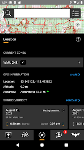
- Use the sunrise / sunset calculator to look up legal hunting light at your location
- See the current moon phase at a glance
- Share waypoints via email to friends and hunting partners
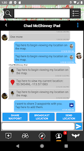
- Text your location to other users
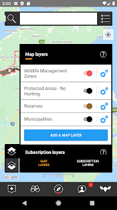
- View the Wildlife Management Areas alongside your WMZs
- Indian Reserve boundary layer
- Municipalities boundary layer
- Chat with other users
- Share waypoints, current location, and your live location
- Track your position as you hunt - get an altitude and velocity profile as well as a track overlaid on the map
- Draw over the map to highlight property lines, animal patterns, or trails
- Search the map for businesses or points of interest (internet connection required)
- Recently viewed and favorites lists for WMZs and waypoints
Public Land Access In-App Subscription ($9.99/year):
Adds 6 additional boundary layers including General Use Crown Land, Private Land, Huntable Public Parks, Deer Wintering Areas, and Leases, Easements & Licenses of Occupation, and Private Conservation Lands.
Features:
- Includes regulation summary for the current season (free updates every year)
- View WMZs on top of base of big-game, predator and game bird seasons
- Add waypoints to the map at your current location, known GPS locations, or where you tap and hold
- Edit the name, description, image and location of your waypoints
- Store Landowner contact information in waypoints to keep track of all your hunting contacts in one place
- Send your friends or family an email with your current location so they can easily find you
- Use the sunrise / sunset calculator to look up legal hunting light at your location
- See the current moon phase at a glance
- Share waypoints via email to friends and hunting partners
- Text your location to other users
- View the Wildlife Management Areas alongside your WMZs
- Indian Reserve boundary layer
- Municipalities boundary layer
- Chat with other users
- Share waypoints, current location, and your live location
- Track your position as you hunt - get an altitude and velocity profile as well as a track overlaid on the map
- Draw over the map to highlight property lines, animal patterns, or trails
- Search the map for businesses or points of interest (internet connection required)
- Recently viewed and favorites lists for WMZs and waypoints
Public Land Access In-App Subscription ($9.99/year):
Adds 6 additional boundary layers including General Use Crown Land, Private Land, Huntable Public Parks, Deer Wintering Areas, and Leases, Easements & Licenses of Occupation, and Private Conservation Lands.
Updated on
Safety starts with understanding how developers collect and share your data. Data privacy and security practices may vary based on your use, region, and age. The developer provided this information and may update it over time.


