MapCam - Geo Camera & Collages
Contains ads
4.6star
4.31K reviews
500K+
Downloads

Everyone
info
About this app
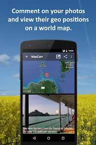
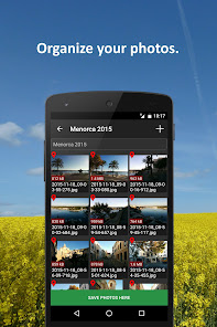
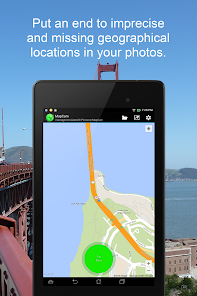
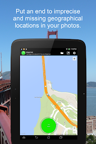
Put an end to imprecise and missing geographical location data (GPS position) in your photos. Organize your photos before taking them by easily selecting a storage folder. Add photo captions to your images. View your photos and their geo positions on a world map. Create impressive geo photo collages and share them with friends.
To do all this, MapCam works together with your favorite camera app and stores additional meta data in your photo files. This enables you for instance to view your pictures and photo captions on a world map at the places where you took them (see my apps EagleEye and PhotoMap). In this way, you can go on a trip again by jumping virtually from location to location.
MapCam offers you the following functions:
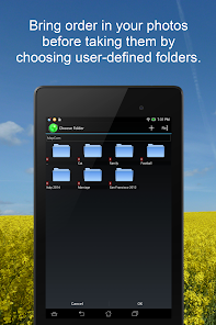
✔ Easily create and select storage folders for your photos before taking them.
✔ Automatic storage of the best available degrees of latitude/longitude and altitude (in metres above sea level) in the Exif data of your photo files.
✔ Add a descriptive text resp. photo caption to your pictures. The text is saved in the IPTC metadata of your photo file and does not change your photo. Picasa is able to read and show these descriptions on your PC.
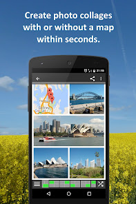
✔ Create geo photo collages (map and photos).
✔ Share your photos just after taking them, e.g. via e-Mail, Facebook, Flickr, Google+, Instagram, MMS, Picasa, Skype, Twitter, WhatsApp, Dropbox etc.
✔ Use existing camera apps. Many apps are compatible, e.g. the most preinstalled ones, Camera MX, Cymera, LINE camera, pudding camera, Camera FV-5 Lite, Camera360 Ultimate etc.
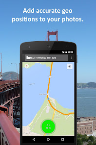
Using MapCam is simple:
1. Click the round button as soon as you are happy with the detected position. The button is light green and big when the current position is precise. It is red and small when the position is imprecise.
2. Take your picture: MapCam starts the default camera app or your selected one and stores the best available position in the Exif data of your photo file.
3. Add a descriptive text and share your photo (optional).
Use MapCam if the position and description of photos is important to you. Here are some examples:
★ When traveling, on vacation, on business trips, when camping, at the beach, at the airport, at the train station, at the museum, etc.
★ Make a note of sites such as real estate, homes, cars, hotels, hostels, restaurants, places of work, schools, parking lots, etc.
★ During sport such as bicycling, rowing, running, jogging, skiing, snowboarding, hiking, exercising, playing football, etc.
★ As a spectator at a special event such as a concert, a festival, a soccer game, a tennis match, etc.
★ As a visitor to a park, flea markets, zoos, amusement parks, Christmas markets, etc.
★ On the weekend family outing, at a party/celebration, at a bar/nightclub, in a club, to record the night life etc.
★ When meeting with friends at the mall, on the playground, while shopping, in a restaurant, etc.
★ On special occasions such as birthdays, weddings, celebrations, parades, etc.
★ In the event of a disaster such as an earthquake, storm surge, flood, tsunami, storm, hurricane, forest fire, etc.
MapCam is interesting for the following occupational groups: real estate brokers, dealers, craftsmen, firefighters, police officers, construction workers, drivers (truck drivers, taxi drivers), event managers, foresters, gardeners, janitors, pilots, soldiers, etc.
To do all this, MapCam works together with your favorite camera app and stores additional meta data in your photo files. This enables you for instance to view your pictures and photo captions on a world map at the places where you took them (see my apps EagleEye and PhotoMap). In this way, you can go on a trip again by jumping virtually from location to location.
MapCam offers you the following functions:
✔ Easily create and select storage folders for your photos before taking them.
✔ Automatic storage of the best available degrees of latitude/longitude and altitude (in metres above sea level) in the Exif data of your photo files.
✔ Add a descriptive text resp. photo caption to your pictures. The text is saved in the IPTC metadata of your photo file and does not change your photo. Picasa is able to read and show these descriptions on your PC.
✔ Create geo photo collages (map and photos).
✔ Share your photos just after taking them, e.g. via e-Mail, Facebook, Flickr, Google+, Instagram, MMS, Picasa, Skype, Twitter, WhatsApp, Dropbox etc.
✔ Use existing camera apps. Many apps are compatible, e.g. the most preinstalled ones, Camera MX, Cymera, LINE camera, pudding camera, Camera FV-5 Lite, Camera360 Ultimate etc.
Using MapCam is simple:
1. Click the round button as soon as you are happy with the detected position. The button is light green and big when the current position is precise. It is red and small when the position is imprecise.
2. Take your picture: MapCam starts the default camera app or your selected one and stores the best available position in the Exif data of your photo file.
3. Add a descriptive text and share your photo (optional).
Use MapCam if the position and description of photos is important to you. Here are some examples:
★ When traveling, on vacation, on business trips, when camping, at the beach, at the airport, at the train station, at the museum, etc.
★ Make a note of sites such as real estate, homes, cars, hotels, hostels, restaurants, places of work, schools, parking lots, etc.
★ During sport such as bicycling, rowing, running, jogging, skiing, snowboarding, hiking, exercising, playing football, etc.
★ As a spectator at a special event such as a concert, a festival, a soccer game, a tennis match, etc.
★ As a visitor to a park, flea markets, zoos, amusement parks, Christmas markets, etc.
★ On the weekend family outing, at a party/celebration, at a bar/nightclub, in a club, to record the night life etc.
★ When meeting with friends at the mall, on the playground, while shopping, in a restaurant, etc.
★ On special occasions such as birthdays, weddings, celebrations, parades, etc.
★ In the event of a disaster such as an earthquake, storm surge, flood, tsunami, storm, hurricane, forest fire, etc.
MapCam is interesting for the following occupational groups: real estate brokers, dealers, craftsmen, firefighters, police officers, construction workers, drivers (truck drivers, taxi drivers), event managers, foresters, gardeners, janitors, pilots, soldiers, etc.
Updated on
Safety starts with understanding how developers collect and share your data. Data privacy and security practices may vary based on your use, region, and age. The developer provided this information and may update it over time.

No data shared with third parties
Learn more about how developers declare sharing

No data collected
Learn more about how developers declare collection
Ratings and reviews
4.6
4.04K reviews

A Google user
- Flag inappropriate
January 22, 2020
I love this App. I use it to document inspections of a tollway system in a major metropolitan area in the US. Before I found this app, geotag locations on many of my photos were not accurate enough to rely on as a documentation source, requiring us to maintain detailed photo logs and waste a lot of time correlating photos to their locations. This app allows me to review the accuracy of the location assigned to the photo right after I take it, so I can retake the photo or edit the location if it isn't correct. The caption functionality allows me to enter my field notes directly into the photo and eliminates the need to track things with pen and paper. I just wish that there were more PC-based software options that take this information further for reporting and integration into other processes.
96 people found this review helpful

narj salazar
- Flag inappropriate
September 1, 2020
I have seen a lot of these apps before but i suggest to add the camera angle/direction of your camera be saved in the metada. But recording audio/voice I think is not needed for this kind of app.
43 people found this review helpful

Thomas Hood
- Flag inappropriate
March 25, 2021
Not useful for me because (1) it invokes the camera such that the latter asks for confirmation after every take; (2) it keeps asking to access location data when the app is not in use, even after this permission has been refused.
27 people found this review helpful
What’s new
✔ Minor improvements
App support
About the developer
Ludger Bischofs
ludger@bischofs.eu
3/117 Victoria Road
Devonport
Auckland 0624
New Zealand
undefined


