Topographie Deutschland MapApp
4.1star
16 reviews
1K+
Downloads

Everyone
info

About this app
This is the premium version of the free app 'Learn federal states: MapApp'.
As a Christmas present, all of my apps are now available free of charge. I had a lot of fun programming. Unfortunately, for personal and professional reasons, I can no longer keep the app up to date. I therefore hope that it will continue to give as many users as possible joy and fun while learning, even without being updated.
With this app you can playfully learn the federal states and neighboring countries of Germany with their capitals, as well as the largest rivers and lakes, the low mountain ranges and many selected cities.
It goes from a simple view of the map, to a quiz that requires quick answers, to a sophisticated learning system based on the card box principle.
If you don't know what to do next, there are helpful explanations to help you use the app as easily as possible.
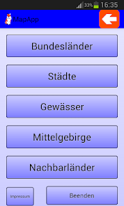
You can choose between different categories in the app.
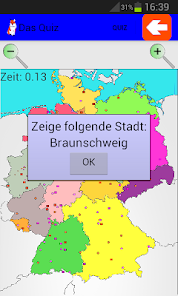
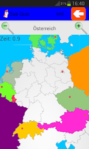
1) You can choose a quiz category in which you can name or show as many answers as possible correctly as quickly as possible for a high score. To do this, you can independently choose what exactly you want to be queried before the quiz. So you can only make a selection or allow all questions to be asked.
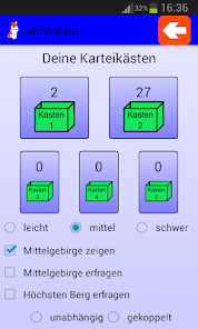
2) There is also a learning category. There is a prefabricated card index box that you can use to study without rushing. Again you can choose whether you want to be queried by simply pointing by tapping the card or by typing in the correct answer. Incorrectly answered questions are put back in Box 1. Correctly answered questions are placed in the next higher box in ascending order to box 5. This is a good way of assessing what you still have to learn and what you have already mastered well.
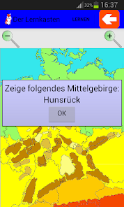
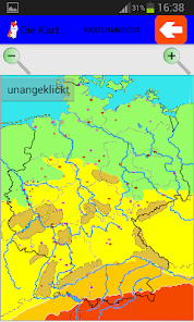
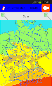
3) Last but not least, there is the option of simply looking at the existing map and clicking through it. So you can see directly what this or that area is on the map.
Each of these categories is available for the selection of federal states with capital cities (also available in isolation as a free app without advertising), cities, bodies of water, low mountain ranges and neighboring countries with capital cities.
For cities, bodies of water and low mountain ranges, several levels of difficulty have now been introduced so that the huge number does not kill you and you can expand your queries in an orderly manner. In the quiz, the ability to choose the elements to be queried is becoming more important, as you can test your knowledge well outside of the learning category (e.g. only query low mountain ranges of the medium difficulty level).
With the cities you can also decide for yourself whether you would like to learn the location and names of the cities on a political or geographical map. Of course, you can switch freely at any time. Regardless of this, the cities can be found in 4 levels of difficulty with 30 cities each.
The largest rivers in Germany are hidden behind the waters. But in more difficult stages you can also find the largest lakes and rivers that are rarely known. If you don't want to learn these, however, they don't block your learning success on large rivers.
In the low mountain ranges you can learn the name of the highest elevation for the low mountain ranges. These are queried like the capitals of the federal states; however, you can just as easily leave them out.
The neighboring country selection is structured in a similar way to the federal state selection, only on an even larger map section.
As a Christmas present, all of my apps are now available free of charge. I had a lot of fun programming. Unfortunately, for personal and professional reasons, I can no longer keep the app up to date. I therefore hope that it will continue to give as many users as possible joy and fun while learning, even without being updated.
With this app you can playfully learn the federal states and neighboring countries of Germany with their capitals, as well as the largest rivers and lakes, the low mountain ranges and many selected cities.
It goes from a simple view of the map, to a quiz that requires quick answers, to a sophisticated learning system based on the card box principle.
If you don't know what to do next, there are helpful explanations to help you use the app as easily as possible.
You can choose between different categories in the app.
1) You can choose a quiz category in which you can name or show as many answers as possible correctly as quickly as possible for a high score. To do this, you can independently choose what exactly you want to be queried before the quiz. So you can only make a selection or allow all questions to be asked.
2) There is also a learning category. There is a prefabricated card index box that you can use to study without rushing. Again you can choose whether you want to be queried by simply pointing by tapping the card or by typing in the correct answer. Incorrectly answered questions are put back in Box 1. Correctly answered questions are placed in the next higher box in ascending order to box 5. This is a good way of assessing what you still have to learn and what you have already mastered well.
3) Last but not least, there is the option of simply looking at the existing map and clicking through it. So you can see directly what this or that area is on the map.
Each of these categories is available for the selection of federal states with capital cities (also available in isolation as a free app without advertising), cities, bodies of water, low mountain ranges and neighboring countries with capital cities.
For cities, bodies of water and low mountain ranges, several levels of difficulty have now been introduced so that the huge number does not kill you and you can expand your queries in an orderly manner. In the quiz, the ability to choose the elements to be queried is becoming more important, as you can test your knowledge well outside of the learning category (e.g. only query low mountain ranges of the medium difficulty level).
With the cities you can also decide for yourself whether you would like to learn the location and names of the cities on a political or geographical map. Of course, you can switch freely at any time. Regardless of this, the cities can be found in 4 levels of difficulty with 30 cities each.
The largest rivers in Germany are hidden behind the waters. But in more difficult stages you can also find the largest lakes and rivers that are rarely known. If you don't want to learn these, however, they don't block your learning success on large rivers.
In the low mountain ranges you can learn the name of the highest elevation for the low mountain ranges. These are queried like the capitals of the federal states; however, you can just as easily leave them out.
The neighboring country selection is structured in a similar way to the federal state selection, only on an even larger map section.
Updated on
Data safety
Developers can show information here about how their app collects and uses your data. Learn more about data safety

No information available
Ratings and reviews
4.1
16 reviews

A Google user
- Flag inappropriate
- Show review history
December 14, 2018
Hat meiner Tochter in der 4ten zu einer 1 verholfen. Lernen von Flüssen und Bergen könnte übersichtlicher gestaltet werden, da Orientierungspunkte nur schwach zu sehen sind. Deutschland ist aber halt ein volles Land.
What's new
1) Die Nachbarländer funktionieren jetzt fehlerfrei.
2) Das Handling wurde verbessert. Unter anderem werden in den Menüs gewählte Einstellungen nach einem Durchlauf beibehalten.
3) Für das beenden in einem Durchlauf ist nun eine zusätzliche Bestätigung nötig. Ebenso, wenn man beim Eintippen keine Eingabe macht.
4) Einige Fehler wurden behoben. Falls Hauptstädte in Lernkästen bereits fehlen, bitte unter "Optionen" alle zurücksetzen.